
Mon Jan 09, 2023 Minimizing the Severing of Land
A few days ago, I showed the frontispiece of my 2023 map projection calendar – the Mercator projection. I mentioned that most of the calendar’s maps will be centered to 10° East, and presented an additional image that I called the OGABO version. Maybe some of you have noticed that the latter is using a slightly different projection center. For comparison, here are both variants again:


I did this because I felt that a representation like this – without graticule and boundary lines –
should avoid interruptions of land areas as much as possible, and after trying a bit, I decided
that a projection center at 11.55° East (or 11°33′0″E), which
equals to a boundary cut along the 168.45° West (or 168°27′0″W) meridian
is the best choice.
I would like to explain this in more detail; and also talk about other ways to avoid interruptions on land areas
– but first off, a few remarks:
- Everything I’m going to say refers (unless otherwise noted) only to “uninterrupted”[1] world maps in equatorial aspect.
- Since Antarctica is arranged around the South Pole, it has to be cut on equatorial world maps. So “not cutting through land areas” actually means “not cutting through any land areas except Antarctica” here.
-
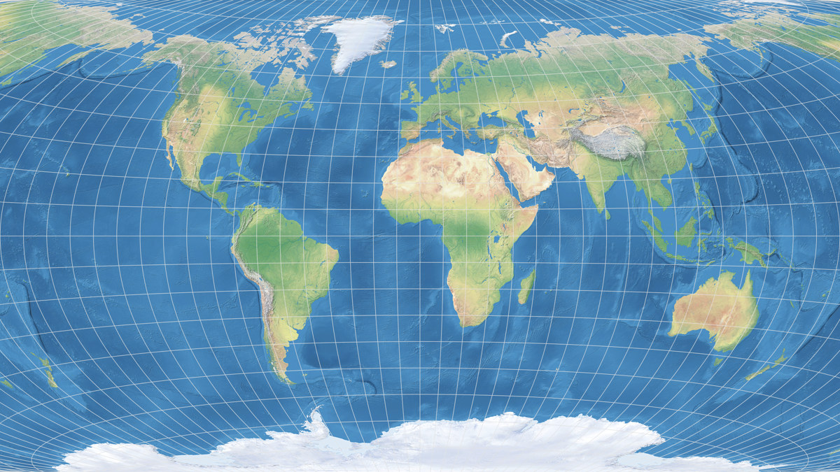
Yes, my preferred 11.55° East will put Europe to the map’s center,
so I may be accused of Eurocentrism. But the thing is – if you
want to avoid to cut through land, you’re out of options. See below.
Nonetheless I will take a quick glance at a Pacific-centric world map at the end of the blogpost. - Experienced cartographers will not learn anything new here. I guess I have to add an “as usual“ somewhere…
The Best Longitude for the Cut
On a standard map in equatorial aspect, you have to cut along a certain meridian. If you want to cut through as little land as possible, the limiting meridian has to run through the Bering strait. Somewhere within the comparatively narrow red marked bar – there just is no other place!


Let’s have a closer look at the area in question. Here’s a more detailed image of the Bering strait – plus some of the Aleutian Islands which are also of interest here. The 170° West meridian is marked as a dashed line for better orientation.

St. Lawrence isn’t exactly a large island, but it’s big enough that I prefer not to cut it. So the cut has to be placed between the Cape Prince of Wales, at 168°10′W, and the easternmost tip of St. Lawrence at 168°39′W. These two limits are marked by the red vertical lines.
You can already see that there is not a single meridian that allows to cut no land at all. In this case it’s one one of the Aleutian Islands, namely Umnak, which has to suffer the severing.
Basically, we’re done here. We’ve got a small stripe of less than half a latitudinal degree in width and it hardly matters where exactly within this area you apply the cut. But now that I have started I want to go all the way. So …
… we’ll take an even closer look. This is an image of the Umnak Island:

Umnak is divided into a northeastern and and southwestern part,
which are connected by an isthmus. It would be wonderful to
cut through this land bridge and leave both parts intact,
but regrettably this isn’t possible using the straight vertical cut we need.
So I tried to leave the northeastern part intact, cutting through the
southwestern part – and vice versa.
Remember that on our final map, the NE part will appear on the left edge on the map
and the SW part on the right. In the following to images I’ve arranged them
in this manner.


I guess it’s mostly a question of taste which variant you prefer.
Personally, I like the one which cuts through the southwestern part of the island better.
And that cut is exactly at the 168.45° West (or 168°27′0″W)
I mentioned in the beginning.
And if you’re as pedantic as I am, you will be glad to learn that (as far as I can tell
from the dataset I’m working with[2]) this really severs only
Antarctica and Umnak – even the smallest pacific islands are
left intact!
And thereby, my preferred map center for uninterrupted
world maps in equatorial aspect is 11.55° East (or 11°33′0″E) –
if it’s important to avoid interruption of land areas as much as possible.

But now I have to admit: Mostly, that’s not very important to me. Mostly, I’m fine with maps that are centered to the Greenwich meridian. I even think the fact that the Chukchi Peninsula, separated from the rest of Siberia, then appears on the left edge of the map, is an advantage, because that gives you an idea of how you need to continue the map (in your mind) beyond its boundaries. I also had other priorities for the calendar, as mentioned recently: using 11.55° East as the central meridian would have resulted in a slightly asymmetrical graticule. That doesn’t look too bad either (see the following example), but it would still have disturbed my eye.

But sometimes it is useful to avoid the severance of land. That’s why is was looking for the best meridian to achieve this. And that’s why I am now coming to other possibilities.
Other Techniques and an Eastern Center
There are other techniques to avoid interruptions on land. I showed one of them in the calendar blogpost of March 2021. In this example, the Winkel Tripel Bartholomew is extended beyond its usual boundaries to fill up a rectangular space:
Or, not forced into a rectangle, an example of Wagner IX which shows the area between 160°W and 180° twice:

While this does avoid all interruptions on land – no matter which part of the Earth you’re interested in, it’s shown uninterrupted somewhere of the map – I’m not very fond of repetitions. But that’s just my opinion, so you don’t have to care about that. What’s worse, no map projection software that I know supports repetitions like this (properly).[3] For the two images shown above, I had to work with a few tricks.[4]
I will come to another technique (that I showed a few months ago in another context) in a moment. But first, let’s look at a Pacific-centered world map. In this case, it is inevitable to cut through other larger land areas besides Antarctica (and yes, I count Iceland as a “larger” land area). I opt for the sparsely populated Greenland – then, the right place to cut is somewhere between the western tip of Iceland (≈ 24°40′W) and the eastern tip of Brazil (≈ 34°30′W):

I choose 26° West, i.e. a map center at 154° East – I’ll spare you
further “proof images”, but this avoids any cuts through Azorean, Cape Verdean
or the South Sandwich Islands.
Furthermore, at least according to
this map,
no cities or other settlements of Greenland are severed.
Here’s a map using this center:

This looks quite acceptable to me.
There is, however, a catch with the pacific-centered maps,
but I’ll go into that in the January February
March April part of this year’s calendar.
Another obstacle can be solved;
if you can’t put up with the severed Greenland, you can use the
“other technique” I mentioned above – which is an extension, that, for example,
may look like this:

Now all cuts through land are avoided, but this leads to an irregular outer shape of the map. Nevertheless, I like this solution better than repetitions. Unfortunately, this does not work with all software either – here, too, I had to resort to a trick; and that only works with cylindrical and “tileable” projections. It consists of cutting out individual parts of a full map and putting them together accordingly – as I showed a few months ago at the example of Markley’s conformal tetrahedral projection.
And there’s another technique.
It has no repetitions or extensions
and yet, avoids the severing of land, including Antarctica and
the pacific islands. It works with every
projection and with each projection software that lets
you set the center without restrictions.
You only have to dismiss the idea of a equatorial map.

In this example the projection center was set to 36° North, 45° East,
with a projection spin of 37° CCW – an oblique or, in this case,
plagal[5] aspect.
And indeed all interruptions on land
are avoided, but of course the arrangement of the continents is quite unusual
and might confuse the map readers.
Something is always wrong. 😉
By the way, 36°N/45°E/37°CCW is not the only configuration that prevents all interruptions of land, there are other that will also do the trick. Especially if you don’t have the ambition to include even the smallest islands (which are not shown on many maps anyway).
Résumé
In standard equatorial maps, there is no way to avoid all interruptions of land. You only can choose which piece of land is to be severed. If avoiding the cuts is desired or mandatory, you can fall back on repetitions, extensions or a plagal aspect.
But don’t overdo your search for the perfect map center! Checking even small islands, like I did, may be relevant for large wall maps. But on a A3- or tabloid-sized map these islands probably won’t even be displayed.
… And one More Thing
Looking at the plagal aspect I’ve shown above, I thought that we should see this kind of world maps more often. Because it is a good way to prevent the severing of land. Because it drastically changes the layout of the continents, reminding us that the usual (equatorial) view at the globe is nothing more but a convention. And because it was sometimes falsely claimed that the Authagraph map would be the only projection that is able to show all continents incl. Antarctica without interruptions.
And therefore, I decided that (almost) all projections of this year’s calendar will also be shown using this plagal aspect. The intro of the 2023 calendar series has been updated accordingly. The pacific-centered variant will only be shown for a few examples, for reasons that’ll become clear then.
References / Footnotes
- ↑ Of course strictly speaking, there is no “uninterrupted” world map – after all, the limiting meridian I talk about is an interruption. But commonly, the term refers to a map that is interrupted only along a single line or at a single point.
- ↑ The data I used to check this were the Natural Earth 1:10m Physical Vectors, more specifically the Coastline and the Minor Islands shapefiles version 4.1.0 (the current version at the time of writing).
- ↑ Note: I’ve got no idea if Avenza MAPublisher offers this feature.
- ↑ For example, on the extended Winkel Tripel I used the approach shown and explained by the member “Piotr” in a thread of the mapthematics forum. Thank you, Piotr!
- ↑ Plagal aspect: A certain kind of oblique aspects. See e.g. the explanation and illustration on quadibloc.com. I’m not sure if it’s really helpful to subdivide the oblique aspects into three sections – but I like the word “plagal”. It’s got a sort of woody quality about it. 😉
Comments
Due to spam posts, comments are now subject to moderation, which means they remain hidden until they are approved by a moderator.
2 comments
Peter Denner
It also literally passes through the building I work in.
Peter Denner
I've been using 168°25' W because it's as far east of the easternmost tip of St Lawrence as it is west of Cape Prince of Wales (when you account for the fact that the same distance along a parallel corresponds to a greater range of longitudes at the more northerly Cape Prince of Wales owing to the convergence of meridians towards the poles), but you make a compelling case for 11°27' W as it only cuts through Umnak once, so now I can't decide!
Peter Denner
Tobias Jung
Damn, guess you’re right. Both Google and Apple Maps indicate that 168°27' cuts through Vsevidof. *shock*
Currently – in order to cut neither the Kigul Island nor the NE part of Umnak – I’m at -168.438191°. But so far I haven’t checked thoroughly if that will cut anything else.
This is going to be harder than I thought… ;-)
 Except where otherwise noted, images on this site are licensed under
Peter Denner
Tobias Jung
In that case, I’d like to add: 11.55° is of course the best choice _rounded_to_two_decimals_. The REAL best central meridian is the one that passes right through your desk!
:-D
Alexandre Canana
Tobias Jung
Alexandre Canana