Tue June 08, 2021 14 Projections for 2021 (Part 6)
If you wonder what this is about at all, you probably didn’t read the intro.
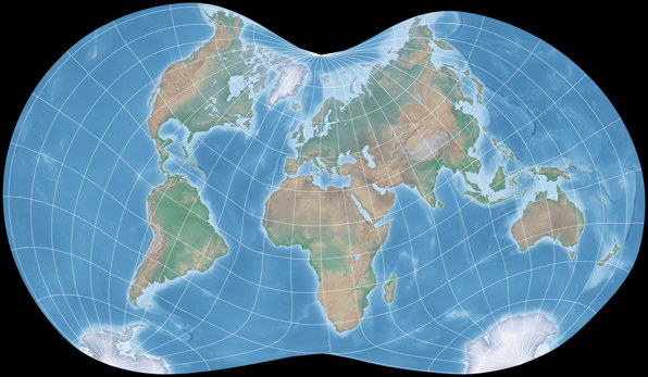
June: Danseiji III
| Danseiji III | |
|---|---|
| Creator | Justin Kunimune (2019) |
| Group | Miscellaneous |
| Property | Compromise |
| Other Names | — |
| Remarks | — |
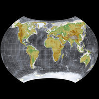
I promised an unusual projection for this month – and that applies to the Danseiji III, doesn’t it?
In 2019, Justin Kunimune presented a new method to create map projections, along with seven examples
of its utilization. They will be added to my website soon and then I’ll also write a bit about them.
So for the moment, I’ll just briefly summarize the properties of Danseiji III:
Like
Strebe 1995,
it pushes the unavoidable distortions as much as possible in the ocean, keeping it away from the
continental areas. The differences are:
Strebe 1995 has pole lines, is equal area and symmetrical, while Danseiji III is a pointed-pole compromise
projection that abolishes any kind of symmetry.
It has both angular and areal distortions – but on land, they are really low.
The arrangement of the continents differs visibly from maps with a straight equator that
we are used to, however it’s still very familiar, so I guess it won’t confuse
anybody too much, not even casual map users.
If you can put up with the unusual appearance (or even welcome it), I think Danseiji III a fine projection for atlas cartography or general-use wall maps.
As I’ve said, I’ll write more about the Danseiji projection soon – if you don’t want to wait, refer to Justin Kunimunes’s blogpost Introducing the Danseiji Projections. And in the next part of my calendar series, we’ll see the first equal-area projection of this year.
My 2021 Map Projection Calendar
To read another part of my 2021 map projection calendar series, select the desired month.







 Except where otherwise noted, images on this site are licensed under
Comments
Be the first one to write a comment!